Developer and Professionals
WILDGOOSE GPS and Navigation Service is the leading producer of Garmin GPS maps for Vietnam. Geospatial data is rare for Vietnam especially when high accuracy is mandatory. In our land survey work we could develop a huge amount of geospatial data which is the base for our WILDGOOSE Vietnam Landmaps.
The Vietnam Landmaps are mainly characterized by high accuracy and good degree of details. For developers and professionals we now offer this geospatial data for your applications or GIS solutions.
Our geospatial data is postprocessed and verified/corrected by rectified orthophotos. Only by this way it is possible to get a high degree of accuracy of the geographic features.
Our service for professional user:
 Geospatial vector data of Vietnam
Our service is to provide geospatial source data for your applications and GIS solutions. This source data is the same used for the Vietnam Landmaps. The accuracy of the data is given with +/- 8 m but usually better. On request other data can be developed if possible.
Geospatial data is available for many areas of Vietnam, but not for all areas. Points, lines and polygons are in Polish Format or as ESRI Shapefile.
Point-of-Interest source data
The POI database included in the Vietnam Landmaps is available as source data for your application or GIS. All points are rectified to get highest possible accuracy. Each point contains the name, the position and usually a description. The points are categorized and will delivered with icon. Fileformat is GPX and icons are in BMP with 16x16x256 in resolution.
Custom vector maps for Garmin GPS units
Custom maps for Garmin GPS receiver are digital maps especially made according to your data or requirements.
Custom maps are used in agriculture or industry as overlay to identify land features in the field. In tourism they are offered by huge ressort to give a detailed map of the facility. In sports custom maps are used by golf courses to identify holes and golf course features by GPS technology.
Tell us how your custom map should look like and we do the development work. Alternately you can also deliver spatial data in Shapefile format for producing your map according to your data and your needs.
Custom vector maps are ideal for
- Agriculture
- Industrial use
- Tourist ressort facilities
- Natur park ressort
- Golf courses
- Amusement parks
Custom vector maps can be produced as own map or as an overlay to be used together with other maps.
Georeferencing of topographic maps and orthophotos
Rastermaps are another kind of digital maps. Used by many navigation or GIS applications rastermaps offer more possibilities at the office and in the field. Such maps can be topographic maps, orthophotos or special purpose maps. Wildgoose GPS and Navigation Service is keen to have an amount of rastermaps on stock.
Our rastermap service also include the production of rastermap of your imagefiles. The rastermaps are in ECW format which is used by many different GIS applications.
Customized GIS and navigation solutions
Special user have special needs. Let us know the tasks which shall fullfil your needs in navigation or GIS work. We provide a customized solution for you.
Examples of special GIS solution:

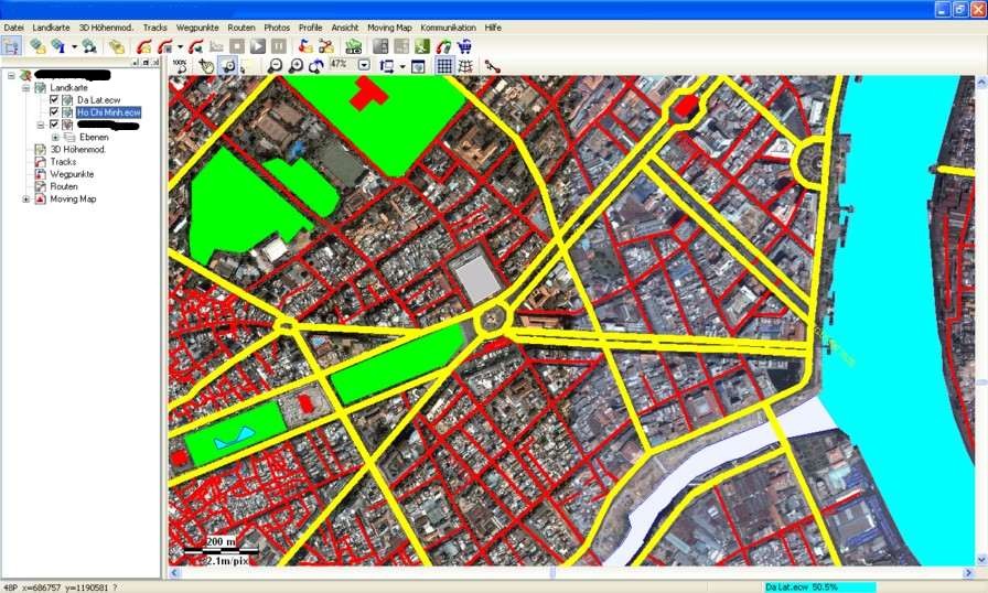
An ESRI Shapefile containing street geospatial data as an overlay on ECW map.
Navigation application using raster map and Garmin Vector map overlay. Application allows to manage huge files of Point-of-Interest and map data.
Remark: Geospatial data and map service is limited due to technical limitation and availability of data.